DE KONING & VAN NIEUWENHUIJZE, Flows in Deventer
Antonio Millán Gómez, Universitat Politècnica de Catalunya
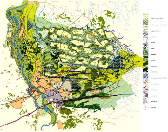 |
1. R. De Koning y L. Van Nieuwenhuize, Landstad Deventer, 2000 For a landscape architect, a plan is the most appropriate representation for the planning, design and layout of a 20,000 ha zone. At first glance we can locate the proposed interventions, while a caption shows the various areas on which work can be done: roads (local, regional, …), works, new housing, water courses, flooded areas, fields (agricultural, forests, farms, …). All this is represented in an originally hand drawn plan, which is then scanned and completed on a computer using Freehand. This plan establishes the various elements and proposed interventions as an ordered combination of them all. How are all these elements (housing, public works, roads, recreational areas, agriculture, forests, water and nature, both existing and proposed) to be combined to achieve a sustainable whole? Water management is the basic design decision; specifically, the lack of adaptation to the water level in some places will make it necessary to consider how it is stored and which measures are to be taken in case of an emergency. The fan-shaped area of land adjacent to to built areas of Olst and Deventer, Zandwetering (light green in the map) seemed well-suited for an ecological filling of earth and forest, where neither new urban districts nor agricultural areas with artificially maintained water levels were allowed. Water collection was limited and new riparian forests together with the existing urban settlements were combined as attractors for small scale new housing clusters. In any case, this was a broad vision presented while transferring from hand drawing to digital manipulation. As in any design situation, the underlying idea was more important than a chromaticism which pleased the eye. It is worth considering the various areas which are introduced and the relationship between them. Also, within each area one must notice how the various elements are inserted and to which category they correspond -note that the selection/classification of areas in the territory is of fundamental importance-. Finally, any change in this sketch is also a modification of the fundamental relationships between topography, use, absence or presence of water, ... This is not a pretty picture but rather a picture of relations of subsistence. |
 |
 |
|
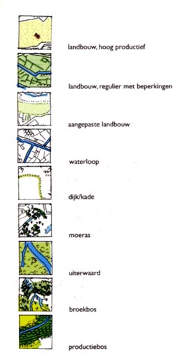
| 2. Landstad Deventer, legend |
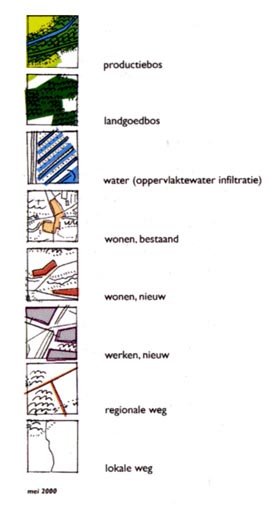
3. Landstad Deventer, legend |
Recommended bibliography:
-
Landstad Deventer 2000
-
Buro N+H+S
© by Antonio Millán Gómez’s texts.
Antonio Millán-Gómez is professor at the Superior Technical Architecture School of Vallès (Escuela Técnica Superior de Arquitectura del Vallès), UPC.
© by Pol Foreman: English translation.
>> Back to the top of the page